Yeşildere, Karaman
Yeşildere | |
|---|---|
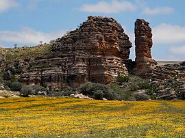
 Yeşildere Rock Formation | |
| Coordinates: 37°10′N 33°30′E / 37.167°N 33.500°E | |
| Country | Turkey |
| Province | Karaman |
| District | Karaman |
| Elevation | 1,200 m (3,900 ft) |
| Population (2022) | 798 |
| Time zone | UTC+3 (TRT) |
| Postal code | 70160 |
| Area code | 0338 |
Yeşildere is a village in Karaman District, Karaman Province, Turkey.[1] Its population is 798 (2022).[2] Before the 2013 reorganisation, it was a town (belde).[3]
Geography
[edit]Yeşildere is 35 kilometres (22 mi) east of Karaman. The town is situated at the south Toros Mountains along the valley of İbrala rivulet.
History
[edit]
The former name of the town was İbrala. Only a few documents about the history of İbrala survive. Probably the town was founded during medieval age, for the mosque of the town had been built on the ruins of a church (The name of the mosque is kilisecamii meaning church mosque) [4] However, there were Christian Turks around Karaman area up to 20th century and the church might be built at a later period. (see Karamanlides) Formerly a village, Yeşildere was declared a town in 1954.
Economy
[edit]Yeşildere is a typical agricultural town. Irrigation has always been a problem . But there is a small dam under construction on the rivulet which is planned to irrigate 13,000 hectares (32,000 acres). Yeşildere residents hope that this may prevent further loss in population.
References
[edit]- ^ Köy, Turkey Civil Administration Departments Inventory. Retrieved 1 March 2023.
- ^ "Address-based population registration system (ADNKS) results dated 31 December 2022, Favorite Reports" (XLS). TÜİK. Retrieved 13 March 2023.
- ^ Law No. 6360, Official Gazette, 6 December 2012 (in Turkish).
- ^ Town page (in Turkish)


